
Fil:Southwest map.png

Storlek på förhandsvisningen: 800 × 520 pixlar. Andra upplösningar: 320 × 208 pixlar | 640 × 416 pixlar | 1 024 × 666 pixlar | 1 280 × 832 pixlar.
Originalfil (1 280 × 832 pixlar, filstorlek: 199 kbyte, MIME-typ: image/png)
| Denna fil tillhandahålls av Wikimedia Commons. Informationen nedan är kopierad från dess filbeskrivningssida. |
Sammanfattning
| Beskrivning |
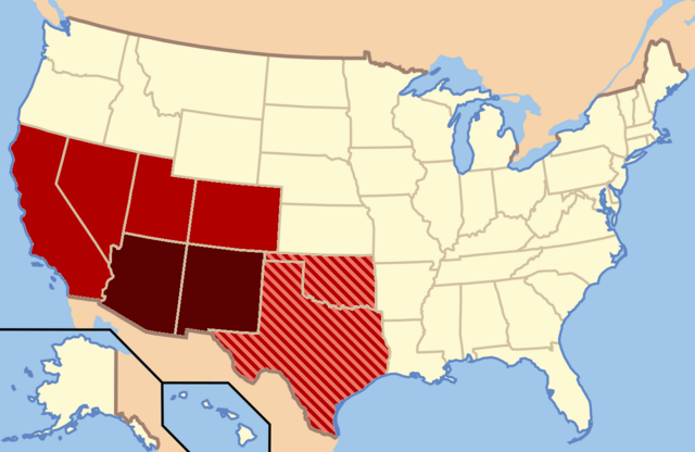
Dark Red: Almost always considered the Southwest |
| Datum | |
| Källa | Eget arbete |
| Skapare | Secret Saturdays |
Licensiering
| Jag, upphovsrättsinnehavaren till detta verk, släpper detta verk i public domain. Detta gäller globalt. I vissa länder kan detta inte vara juridiskt möjligt; i så fall: Jag ger härmed envar rätten att använda detta verk för alla ändamål, utan några villkor, förutom villkor som lagen ställer. |
Filhistorik
Klicka på ett datum/klockslag för att se filen som den såg ut då.
| Datum/Tid | Miniatyrbild | Dimensioner | Användare | Kommentar | |
|---|---|---|---|---|---|
| nuvarande | 9 februari 2022 kl. 05.20 | | 1 280 × 832 (199 kbyte) | Quackslikeaduck | Reverted to version as of 20:03, 25 August 2016 (UTC); Kansas is not considered part of the American Southwest, not even geographically. |
| 31 juli 2020 kl. 23.39 |  | 1 280 × 832 (159 kbyte) | Rubensbathsheba | Kansas may sometimes be considered part of the Southwest geographically. | |
| 25 augusti 2016 kl. 22.03 |  | 1 280 × 832 (199 kbyte) | WClarke | Instead of using dark red, red, and blue stripes, this version uses dark red, red, and red stripes. Everything being red makes the map look more uniform. | |
| 24 juli 2009 kl. 00.53 |  | 572 × 371 (21 kbyte) | Secret Saturdays | {{Information |Description={{en|1=The Dark Red states mean they are almost always considered Southwest states, The light red states mean they are rarely considered Southwest states and the Blue States mean they are conisdered Southwest and Southern states |
Filanvändning
Följande sida använder den här filen:
Global filanvändning
Följande andra wikier använder denna fil:
- Användande på ar.wikipedia.org
- Användande på cs.wikipedia.org
- Användande på de.wikipedia.org
- Användande på en.wikipedia.org
- Användande på eo.wikipedia.org
- Användande på fy.wikipedia.org
- Användande på he.wikipedia.org
- Användande på id.wikipedia.org
- Användande på ko.wikipedia.org
- Användande på ru.wikipedia.org
- Användande på tr.wikipedia.org
- Användande på ur.wikipedia.org
- Användande på vi.wikipedia.org
- Användande på www.wikidata.org