
Fil:European Middle Neolithic.gif
Storlek på förhandsvisningen: 800 × 397 pixlar. Andra upplösningar: 320 × 159 pixlar | 640 × 317 pixlar | 1 307 × 648 pixlar.
Originalfil (1 307 × 648 pixlar, filstorlek: 101 kbyte, MIME-typ: image/gif)
| Denna fil tillhandahålls av Wikimedia Commons. Informationen nedan är kopierad från dess filbeskrivningssida. |
Sammanfattning

|
Det finns en vektorversion av denna rasterbild (SVG).
När vektorbilden är lämpligare ska den användas istället för rasterbilden. File:European Middle Neolithic.gif → File:European-middle-neolithic-en.svg
För mer information om vektorgrafik, se artikeln Commons transition to SVG (på engelska). |
 |
.
| Beskrivning |
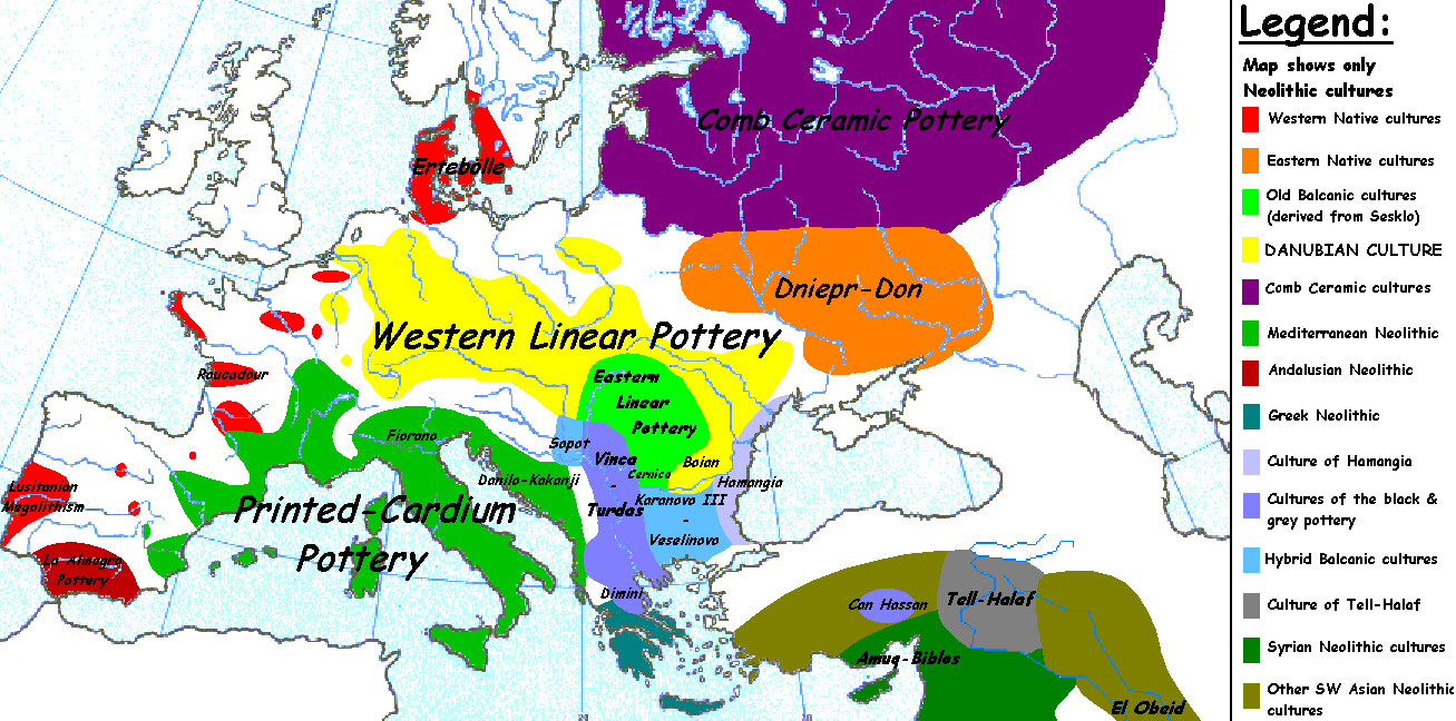
English: Map of the second half European Middle Neolithic at the apogee of Danubian and Mediterranean expansion. (The modification of the original map - Combed pottery, earlier notated as Pitted Ware, see history without respecting the color code of the legend is something that I am not fully satisfied with). |
| Datum | 5 april 2005 (ursprungligt uppladdningsdatum) |
| Källa | Överförd från en.wikipedia till Commons. |
| Skapare | Later versions were uploaded by Clarifer at en.wikipedia. |
| Andra versioner |
[]
|


_en.png)
.png)
.jpg)
Licensiering
| Detta verk har gjorts tillgänglig som public domain av dess skapare, Sugaar på engelska Wikipedia. Detta gäller globalt. I vissa länder kan detta inte vara juridiskt möjligt; i så fall: Sugaar ger envar rätten att använda detta verk för alla ändamål, utan några villkor, förutom villkor som lagen ställer. |
Ursprunglig uppladdningslogg
Den ursprungliga beskrivningssidan fanns här. Alla följande användarnamn finns på en.wikipedia.
- 2005-08-28 13:11 Clarifer 1320×663×8 (106148 bytes) Added the approximate area of the Comb Ceramic culture. Source: National Board of Antiquities, Finland. www.nba.fi
- 2005-04-05 20:12 Sugaar 1320×663×8 (103228 bytes) Map of the second half European Middle Neolithic at the apogee of Danubian and Mediterranean expansion (c. 4500-4000 BCE). Made by [[Sugaar]]. Free use authorized by the author.
Filhistorik
Klicka på ett datum/klockslag för att se filen som den såg ut då.
| Datum/Tid | Miniatyrbild | Dimensioner | Användare | Kommentar | |
|---|---|---|---|---|---|
| nuvarande | 18 april 2014 kl. 08.43 | | 1 307 × 648 (101 kbyte) | Spiridon Ion Cepleanu | Neolithic shorelines and banks, little details |
| 22 mars 2010 kl. 02.39 |  | 1 307 × 648 (101 kbyte) | Ras67 | cropped | |
| 14 februari 2007 kl. 02.50 |  | 1 320 × 663 (104 kbyte) | 32X | Auf eine alte Version zurückgesetzt | |
| 14 februari 2007 kl. 02.49 |  | 1 320 × 663 (101 kbyte) | 32X | Original version by Sugaar. | |
| 31 december 2005 kl. 13.14 |  | 1 320 × 663 (104 kbyte) | Glenn | Originally uploaded to en-wiki: Quote: "Map of the second half European Middle Neolithic at the apogee of Danubian and Mediterranean expansion (c. 4500-4000 BCE)." Upload text: "20:12, 5 April 2005 . . Sugaar . . 1320x663 (103228 bytes) (Map of the secon |
Filanvändning
Följande 2 sidor använder den här filen:
Global filanvändning
Följande andra wikier använder denna fil:
- Användande på az.wikipedia.org
- Användande på be.wikipedia.org
- Användande på bg.wikipedia.org
- Användande på bs.wikipedia.org
- Användande på ca.wikipedia.org
- Användande på cs.wikipedia.org
- Användande på da.wikipedia.org
- Användande på da.wikibooks.org
- Användande på de.wikipedia.org
- Användande på en.wikipedia.org
- Användande på et.wikipedia.org
- Användande på fi.wikipedia.org
- Användande på fi.wikibooks.org
- Användande på gl.wikipedia.org
- Användande på he.wikipedia.org
- Användande på hi.wikipedia.org
- Användande på hr.wikipedia.org
- Användande på hu.wikipedia.org
- Användande på it.wikipedia.org
Visa mer globalt användande av denna fil.