
Fil:Borders of Four Corners, USA survey years.svg

Storleken för denna PNG-förhandsvisning av denna SVG-fil: 240 × 250 pixlar. Andra upplösningar: 230 × 240 pixlar | 461 × 480 pixlar | 737 × 768 pixlar | 983 × 1 024 pixlar | 1 966 × 2 048 pixlar.
Originalfil (SVG-fil, standardstorlek: 240 × 250 pixlar, filstorlek: 63 kbyte)
| Denna fil tillhandahålls av Wikimedia Commons. Informationen nedan är kopierad från dess filbeskrivningssida. |
Sammanfattning
Licensiering
Jag, upphovsrättsinnehavaren av detta verk, publicerar härmed det under följande licenser:
| Denna fil har gjorts tillgänglig under licensen Creative Commons Erkännande-Dela Lika 3.0 Unported | ||
| ||
| Detta licenstillägg lades till till denna fil som en del av GFDL:s licensuppdatering. |

|
Tillstånd ges att kopiera, distribuera och/eller modifiera detta dokument under villkoren i GNU Free Documentation License, Version 1.2 eller senare version publicerad av Free Software Foundation, utan oföränderliga avsnitt, framsidestexter eller baksidestexter. En kopia av licensen ingår i avsnittet GNU Free Documentation License. |
Du får själv välja den licens du vill använda.
Ursprunglig uppladdningslogg
This image is a derivative work of the following images:
- File:Blank_US_Map.svg licensed with Cc-by-sa-3.0-migrated, GFDL
- 2013-03-30T15:24:52Z Wylve 959x593 (61609 Bytes) update coding to allow css styling of States
- 2013-03-30T15:02:40Z Wylve 959x593 (66022 Bytes) optimized code
- 2009-11-05T19:44:02Z NuclearVacuum 959x593 (91518 Bytes) minor fix from previous upload
- 2009-11-05T19:39:42Z NuclearVacuum 959x593 (88399 Bytes) Fixed up the borders so they are connected with each state and loosing that gap between them.
- 2008-10-09T16:36:40Z Howcheng 959x593 (80121 Bytes) Reverted to version as of 08:32, 14 June 2007
- 2008-03-12T00:20:02Z AMK1211 959x593 (174744 Bytes) Added borders: Light blue for water borders and black for land borders (international borders thicker).
- 2007-06-14T08:32:47Z Fibonacci 959x593 (80121 Bytes) Optimised code.
- 2006-07-12T23:00:30Z Theshibboleth 959x593 (90537 Bytes) The line framework around Alaska and Hawaii has been pushed a bit
- 2006-07-12T06:35:19Z Theshibboleth 959x593 (89828 Bytes) added DC
- 2006-07-12T06:05:05Z Theshibboleth 959x593 (89649 Bytes) {{Information |Description=A blank map of the United States in scalable vector form. |Source=Own work, based on [[:Image:Electorial map.svg]], inspired by [[:Image:BlankMap-World.png]] |Date=11 July 2006 |Author=[[User:Theshi
Uploaded with derivativeFX
Filhistorik
Klicka på ett datum/klockslag för att se filen som den såg ut då.
| Datum/Tid | Miniatyrbild | Dimensioner | Användare | Kommentar | |
|---|---|---|---|---|---|
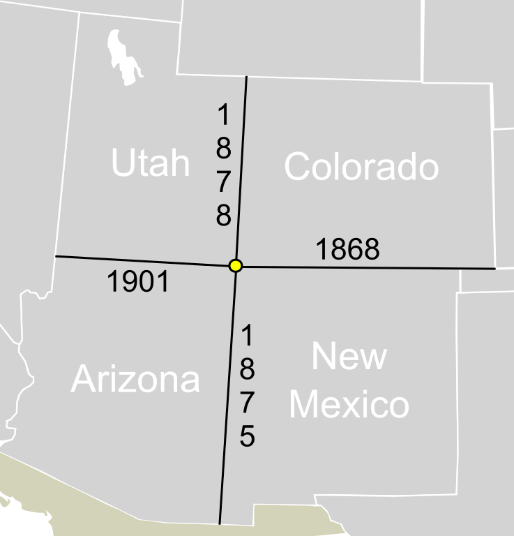
| nuvarande | 8 juni 2013 kl. 23.43 | | 240 × 250 (63 kbyte) | Mangoman88 | == {{int:filedesc}} == {{Information |Description=A map showing the borders that make up {{w|Four Corners, United States}}. The years the borders were officially surveyed and marked are show. |Source={{Derived from|Blank_US_Map.svg|display=50}} author:... |
Filanvändning
Följande sida använder den här filen:
Global filanvändning
Följande andra wikier använder denna fil:
- Användande på en.wikipedia.org